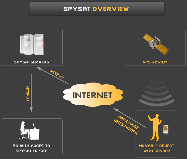
Free GPS tracking platform - architecture of SpySat
Introduction to GPS Tracking platforms
SpySat is a comprehensive free gps tracking platform which main purpose is to provide GPS tracking in real-time.
Our solution complex so which means that it covers the all necessary components that you need to start GPS Tracking in real time like:
- GPS Tracking Server - cloud servers that receive HTTP data packets from GPS Trackers which contatins GPS coordinates
- GPS Trackers - as tracking devices you use phones, tablets and wearables like smart watches which special software
- GPS Tracking website - the site that you are now browsing. After login you can see your trackers real time position on the map

Introduction to the GPS Tracking
To understand The Concept of real time GPS tracking, first you need to have some technical background of tracking, GPS, triangulation and so one.
First some, memorandum from secondary school and geometry. To describe any object in 3 dimensional space (3D) you need to provide 3 variables - called dimension measures. Each of these values represent one dimension (axis), which are usually called X,Y,Z or length, height, depth.
In the real time World condition we know that planet Earth is very similar to sphere - very very big sphere. We use paper or digital map that is a part of the spherical surface translated into flat 2D space because it is much more convenient. This process is called projection or mapping like very known The Mercator Projection but it is not the case this time.
For even large areas the curvature of the Earth could be omitted. If is much easier to carry flat map that a globe. Just imagine people traveling with a giant globe model. For the car or foot travel - paper map is good enough.
If we want to describe the location of any object that is located on the earth's surface (like building, human, car, vessel) we don’t need 3D space but only 2 dimensional space described by Longitude and Latitude, hich refers to X,Y axis angle values (in radians or degrees and minutes ) that could be simply mapped flat 2D linear space. This simplification and nomenclature is still widely used.
People were drawing maps for centuries for many purposes. The wanted to copy part of the earth terrain structure into flat picture seen above.We called them cartographers and their role in modern World development is very significant. They introduced those terms like Longitude and Latitude and thanks to them the World developed so fast.
Maps makes the navigation, transport, trading, journeys, expeditions and whole logistic much easier.
So if you need to localize or track an object on the earth you just need those 2 dimensional space described by those two values: longitude (called lon for shortcut) and latitude (called lat)
This pair of latitude and longitude is called the coordinates and it is sufficient to point exact location on the earth's surface.
In modern geo-location systems like GPS or GLONASS that are used in navy, transport, military we still use the coordinates to exchange , share localisation information.
OK, you mhow to describe the location of plane using 2D lat and lon which was invented for object on the surface ?
Well, as we spoke at the geometry basic before - we just need to and another dimension , called height.
So to describe the location of a plane in the air we say: The plane is 35 Degrees North Latitude 119 Degrees West Longitude and the height is 1500 meters.
How this platform works ?
With SpySat is possible to track any phone, smart watch or tablet on the globe and display its location on a digital map available on our site. The diagram below show the basics of SpySat's tracking methodology and includes the following elements:
1) Site SpySat.eu - GPS Tracking website
2) SpySat Receiving Servers - GPS Tracking servers
3) Mobile devices equipped with GPS and Internet connection (GPS Tracker)
4) Satellite and terrain maps provided by Google Maps (Client browsing GPS Tracking website)

The basic process is as simple as this:
- The GPS Tracker receives GPS Coordinates (latitude and longitude) from the GPS Sattelite networks using radio GPS Receiver
- GPS Coordinates and transformed into HTTP request and with your credential sent to the SpySat Servers
- Spysat server which is a part of GPS Tracking platform - receives message with GPS Coordinates and save it immediately into database
- Using SpySat Tracking website, after login you are able to see the current (real-time) position on the map and browse the history
Thanks to that that all those actions happens very fast (in a seconds) - you can have a real-time view about the location of tracked object (GPS Tracker - in this role could be phone, tablet or even fit tracker)
Free GPS Tracking platform for everyone
Many companies all over the world offer exactly the same technology for money. SpySat is totally free and has the same features like commercials products. It is also a 100% safe and capable of being applied in many applications.
What's more - If you are a programmer - by providing technical documentation of our protocol you can communicate with our servers by your own software - SpySat is an open platform for developers and additionally allows you to export the recorded data to external systems.
On those pages you can find a description how to build and run your own tracking for free. We offer you the collection and storage of location data on our servers, and their subsequent imaging on Google maps.
Please fell free if you have any questions or suggestions about our services.
Find out more in our GPS Knowledge database
(c) Spysat 2024 - Free Real Time GPS Tracking Platform | Privacy Policy | AMLD6 | Shop | PEP Check
